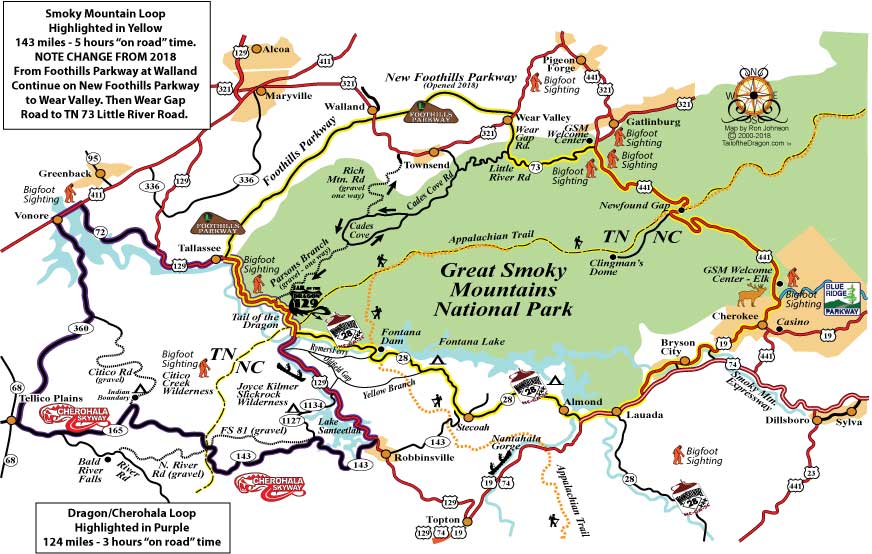
Smoky Mountain Loop
Written By Ron Johnson
Edited by Jessica Green
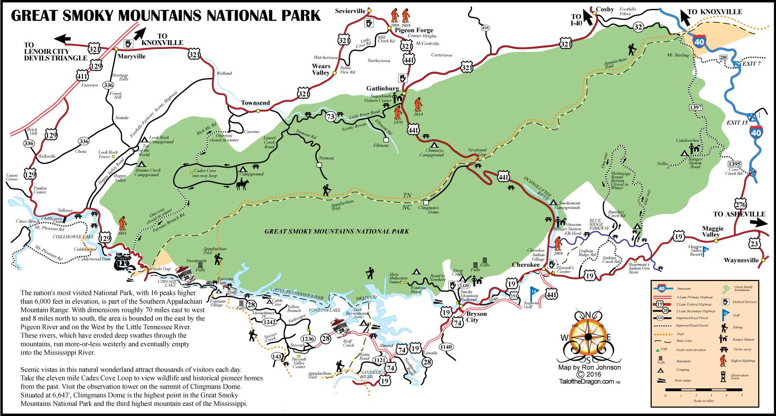
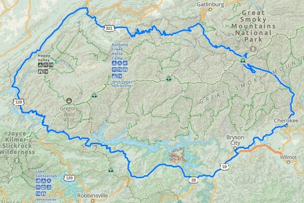
The Smoky Mountain Loop features five of the top touring roads in eastern Tennessee and western North Carolina. The route begins with the exhilarating Tail of the Dragon, continues along the Foothills Parkway and Little River Road, then crosses US 441—the only highway through Great Smoky Mountains National Park. From Cherokee, NC 19 connects you to Moonshiner 28 (NC 28) before looping back to the Tail of the Dragon. This 143-mile loop highlights the park by both skirting its borders and crossing its scenic heart, making it an action-packed route filled with stunning views and popular attractions—a perfect day trip.
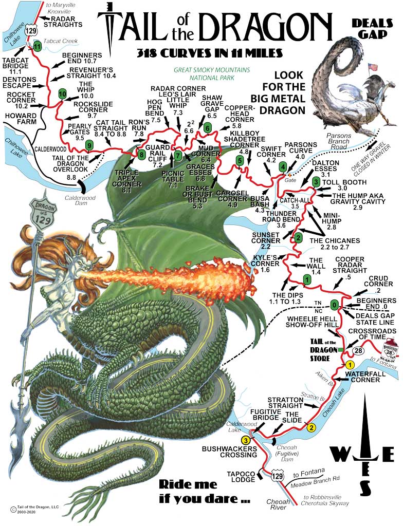
Starting at the US 129/NC 28 intersection in North Carolina, the Tail of the Dragon features 318 curves within just 11 miles. Carved along the edge of the Great Smoky Mountains to your right, this route is the most iconic riding area on the Smoky Mountain Loop. The Tail of the Dragon ends as you cross Tabcat Bridge at Chilhowee Lake.
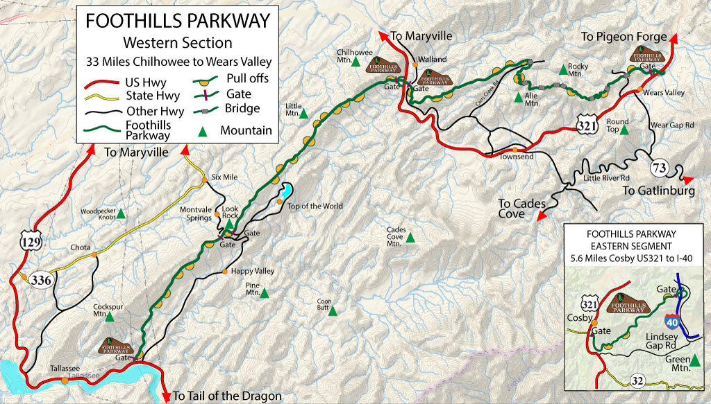
Crossing Tabcat Bridge, US 129 straightens as it follows the shoreline of Chilhowee Lake. The entrance to the Foothills Parkway will be on your right, approximately 3 miles from Tabcat Bridge. The next 17 miles along the Foothills Parkway provide breathtaking views of the Tennessee Valley to the west and the Great Smoky Mountains to the east.
At the Walland/US 321 exit, take a right into Townsend, where you can refuel with gas and food. Townsend has grown significantly over the years and is now considered a gateway to the Great Smoky Mountains. Leaving Townsend, continue straight onto TN 73, also known as Little River Road. This 20-mile, two-lane road winds through some of the most scenic mountain areas in the region. Years ago, Reader’s Digest named it one of the top ten scenic roads in America.
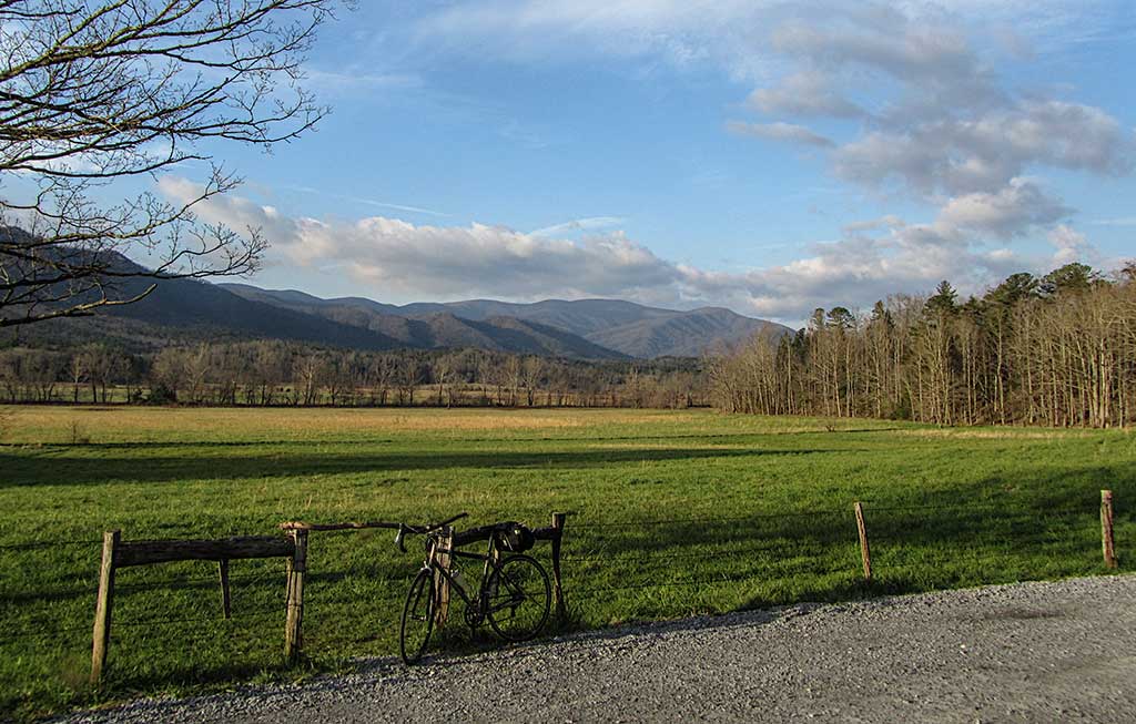
Along Little River Road (TN 73), you will find a short detour on the right called Cades Cove. This 11-mile, one-way loop circles a hidden mountain valley featuring period settler homes, farms, cemeteries, and churches. Warning: There are only three ways out of the loop—two are one-way gravel roads, and the third is to complete the entire loop. The 11-mile drive typically takes about an hour or more. We highly recommend taking this tour early in the morning before crowds arrive.
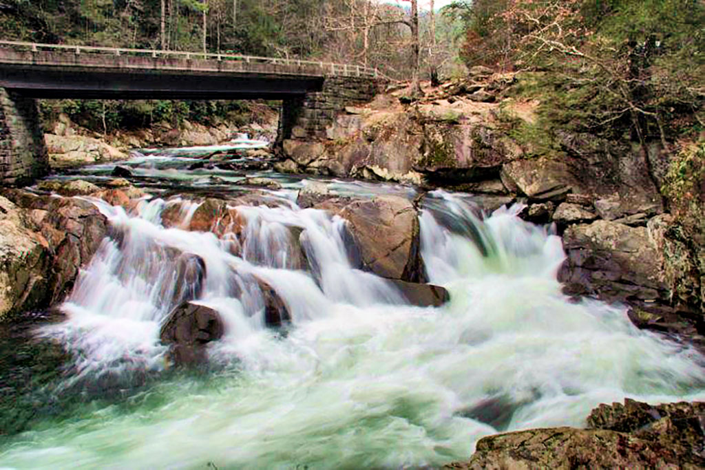
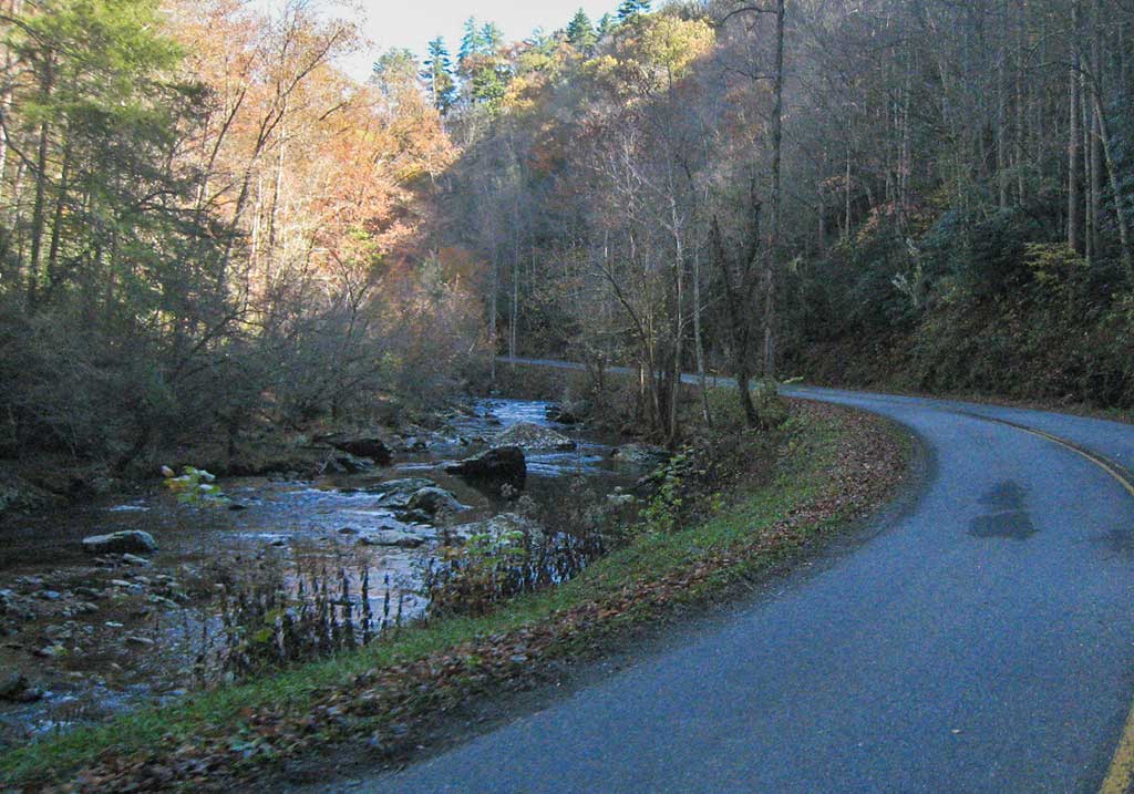
Back on Little River Road, you’ll find numerous scenic pull-offs, hiking trails, and picnic spots. As the road winds through the mountains, you’ll often see people drifting down the river on tubes or enjoying the crisp mountain water from the banks. At the end of Little River Road, you’ll reach the Sugarlands Visitor Center and Great Smoky Mountains National Park Headquarters. Stop in to learn about the park’s history.
A few miles north of the Park Headquarters is the famed town of Gatlinburg, a popular detour offering local dining, shopping, and activities. Be warned: the roads are often crowded with cars, parking is limited, and sidewalks are filled with tourists. This detour can add hours to your trip, especially on weekends.
Continuing on the Smoky Mountain Loop, take a right at Sugarlands onto US 441, also known as Newfound Gap Road, and climb 39 miles to the top of Newfound Gap at 5,046 feet elevation. There is a scenic rest area here with stunning views looking east. Want to detour to the highest point in the Smokies? From Newfound Gap, take Kuwohi Road (formerly Clingmans Dome Road) 5.6 miles to the parking area at 6,311 feet elevation, then hike to the lookout tower at 6,643 feet.
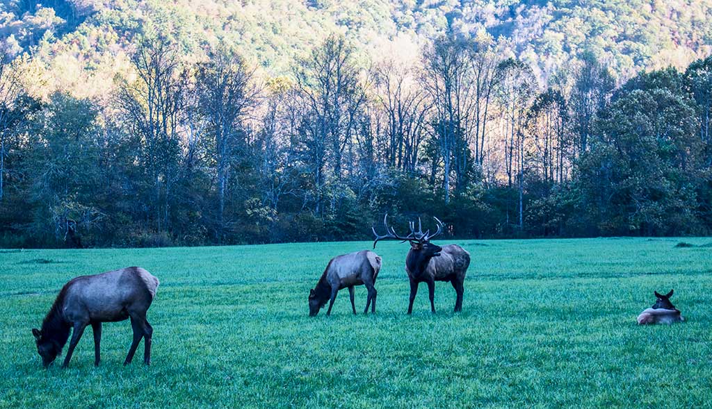
From Newfound Gap on 441 you will continue the Smoky Mountain Loop as you wind down 17 miles into Cherokee. Along the route, you’ll pass several parking areas, the Oconaluftee Visitor Center, and the southern terminus of the Blue Ridge Parkway. Keep an eye out for the local elk herd in this area. The visitor center features an engaging walk through an old settler’s village, complete with guinea fowl and chickens. Once in Cherokee, you’ll have plenty of options to spend on food, fuel, and even a chance to try your luck at the local Harrah’s Casino.
From Cherokee, take US 19 west through Bryson City to US 74, a four-lane highway connecting to Moonshiner 28. Follow NC 28 west (also known as Moonshiner 28) for 32 miles back to the starting point at the Tail of the Dragon. Moonshiner 28 features Fontana Dam—the largest dam east of the Mississippi—and offers great twisty roads for motor enthusiasts to enjoy.
More Activities Along the Route:
• Townsend: Town offering local dining, accommodation, and activities.
• Kuwohi (formerly Clingman’s Dome Road): Home to the highest point in the Smokies at 6643 feet.
• Cherokee: A mountain town with local dining, accommodation, and activities.
Tips for the Best Travel Experience:
• Plan your fuel stops ahead, as there may be stretches of up to 50 miles between gas stations.
• Although this is only a 150-mile loop, allow a full day or two to enjoy the numerous iconic stops along the way.
• To avoid heavy traffic, travel Little River Road (TN 73) and US 441 early in the day.
HISTORY
Written By Ron Johnson
Edited by Jessica Green
Smoky Mountains – US 441
The Smoky Mountains are a mountain range that is part of the Appalachians, straddling the border between North Carolina and Tennessee. Around 14,000 years ago, Native Americans inhabited the area, building villages on both sides and traveling along rugged foot paths originally created centuries earlier by wild animals.
The main route followed what was once called the Indian Gap Trail, stretching from present-day Gatlinburg to the summit at Indian Gap, which sits at an elevation of 5,390 feet, then winding down to present-day Cherokee. Today’s US 441 parallels this early trail, passing nearby through Newfound Gap at 5,087 feet.
Until the mid-1700s, Native Americans were the sole inhabitants of this area. European explorers and settlers began arriving in greater numbers afterward. By the early 1800s, settlers had established communities on both sides of the still-wild mountain range. The Native American population suffered greatly, and in 1830, the Trail of Tears forced the relocation of the Cherokee to Oklahoma. As more settlers arrived, the footpaths were improved to accommodate wagons, but these early roads were often poorly maintained and dangerous.
By the time of the Civil War, both Union and Confederate soldiers roamed the area. Also present were “bushwhackers” who shifted their allegiance between sides based on convenience. These highwaymen cared only about what they could steal, killing anyone who stood in their way.
The first logging operations in the Smokies began in the 1880s as resources in more easily accessible forests were depleted. Early loggers used rivers to transport logs to nearby mills. By the early 1900s, new technology allowed railroads to take over transportation.
Between 1909 and 1920, several entrepreneurs from Knoxville began efforts to promote tourism on the western slopes along the Little River, and the idea of creating a National Park first emerged. Land purchases were nearly complete by 1932, and the Great Smoky Mountains National Park was dedicated by President Franklin Roosevelt in 1934 at Newfound Gap.
By that time, a crude roadway had been completed from Gatlinburg to Newfound Gap, while the section descending to Cherokee was still under construction. Today US 441, the main route through the Smokies, is a modern highway. As of 2025, Great Smoky Mountain National Park is the most visited National Park in the United States.
TN 73 – Little River Road
This scenic highway largely follows the Little River as it cuts through rock cliffs on either side of the road. The area was first explored and developed by logging companies in the 1880s, who graded land and laid railroad tracks along the river.
By the early 1900s, several people began promoting the area as a tourist attraction. Crude roads were built over the existing railroad beds after the logging companies were bought out. By the 1930s, the area became part of the Great Smoky Mountains National Park project. Today, TN 73 is a popular touring road—sometimes crowded—and was listed by Reader’s Digest as one of the ten most scenic roads in America.
Tail of the Dragon
Tail of the Dragon—famous for its 318 curves in just 11 miles—is America’s most thrilling destination for motorcycle riders and sports car enthusiasts. Carved between the Great Smoky Mountains and Cherokee National Forest, this iconic stretch offers a pure driving experience and a vast history. [More Info: Tail of the Dragon History]
Foothills Parkway
Congress authorized the Foothills Parkway as a 72-mile scenic parkway on February 22, 1944. Today, only three segments totaling 38.6 miles are open to the public. [More Info: Foothills Parkway Info & History]
Moonshiner 28
Portions of Moonshiner 28 (NC 28) date back to 1922. This area of the Appalachian Mountains has a rich history of moonshining and violence. [More Info: Moonshiner 28 Info & History]


Printable Maps